We use cookies to understand how you use our website, to remember your settings and improve our services. We also use cookies set by other sites to help us deliver content from their services. If you accept the cookies and then change your mind, you can remove them in your browser settings.

Flooding advice for North Somerset residents

This page contains information about flooding in North Somerset, including:

  • causes of flooding
  • flood risk
  • sea defences
  • council developments on flood plains
  • preparing your community
  • road gullies

Causes of flooding

Flooding from the sea happens due to storms that cause sea levels to rise and large waves to form. If the wind is blowing onshore and the tide is also high, then flooding is possible. 

Flooding can also happen due to rainfall, especially if it is heavy over a short period of time. It can also happen if there is constant rainfall over an extended amount of time.

Flood risk

Around 5.2 million properties in England, or one in six properties, are at risk of flooding, according to the Environment Agency.

Coastal flood risk

This map shows the combined risk of flooding from rivers and the sea. It also shows surface water flood risk, which is sometimes known as flash flooding. 

There is a widespread risk across North Somerset of flooding from surface water or flash flooding. This can also impact people living on a hill.

Flood risk in North Somerset

We're aware of local media coverage that included a map that reportedly showed flood risk in the area. 

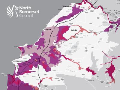
It's important for people to understand that this map shows where the sea would be if we didn't have any sea defences in place. We do of course have sea defences in North Somerset so this map was not accurate.

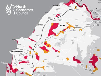
Map A below shows flood risk without any sea defences. Map B shows an accurate picture of the current flood risk to North Somerset, taking into account current sea defences and showing the risk of flooding from rivers.

A map showing the risk of flooding in North Somerset without defences in place
Map A: Flood risk without defences in place
A map showing the current risk of flooding in North Somerset with flood defences in place
Map B: Flood risk with defences in place

Sea defences

With the second-highest tidal range in the world, the tide along the North Somerset coast rises quickly and the current can be strong.

During high tides, we carefully monitor the following things. These are important tools to indicate whether flooding is likely to happen: 

  • tide heights 
  • wind speed 
  • wind direction 
  • wave buoy data 
  • weather and flood forecasts

We rely on Environment Agency warnings along with our own observations. If there is an increased risk of flooding from the sea, we will make a decision to deploy the sea defence gates in Weston-super-Mare. If we do this, we also tell residents and businesses along our seafronts. 

Clevedon 

If there is an increased risk of flooding from the sea, we may close The Beach in Clevedon. 

Residents should be aware that high tides and strong winds may throw debris into the road. 

We are currently investing in restoring the Victorian sea walls to improve their strength. To find out more, read this article from our September 2023 edition of Life email newsletter.

Portishead

We may close Esplanade Road in Portishead if there is increased risk of flooding from the sea. 

Residents should be aware that high tides and strong winds may throw debris into the road. 

Weston-super-Mare

There are flood defence walls, including 12 tide gates, along the promenade in Weston-super-Mare. These give extra protection for homes and businesses in the town. We may close the gates in various combinations depending on the level of risk expected. 

We are currently investing in restoring the Victorian sea wall near Anchor Head to improve its strength. To find out more, read this article from our September 2023 edition of Life email newsletter.  

The sand dunes at either end of Weston-super-Mare - at Uphill and Sand Bay - also form an important part of the natural sea defences for the surrounding area. 

We are currently trialling fenced off areas of the dunes to encourage vegetation to grow and strengthen the dunes. To find out more, read our news release from June 2023

Council developments on flood plains

We follow national planning policy for all new projects. This includes carrying out a strategic flood risk assessment across the area. We use this assessment as evidence of where large new developments should go. This informs our Local Plan 2039, which you can read more about on our Local Plan pages

When a developer applies for planning permission, they must demonstrate that the scheme is not at risk of flooding or that it will not increase flood risk elsewhere. This will often mean the developer plans to raise the level of the land so it no longer floods.  

A developer may also install large storage areas within the development to capture surface water runoff. These storage areas then slowly release any captured water which makes sure that flood risk is not increased. 

Improving infrastructure

Developers may also financially contribute towards improving significant flood risk infrastructure, such as installing new sea walls. 

Over the last eight years, we have invested over £3.2m in large schemes to reduce flood risk in Wrington and Weston-super-Mare (Summer Lane).  

We spend over £1m a year to maintain road drainage and flood defences. We have also started to use new techniques such as natural flood management and property level flood resilience to reduce flood risk in North Somerset. 

The climate emergency and flood risk

We’ve already started to factor in predicted impacts of the climate emergency into our Local Flood Risk Management Strategy.

Climate change will cause wetter winters and drier summers. We will also see more frequent and more powerful storms, which are likely to cause localised flooding. 

Sea levels have already begun to rise as a direct result of climate change. Over the next 100 years, sea levels are predicted to rise by a further 1.2m. 

Home insurance and flood risk

Your premium will already take into account the level of risk for the area that you live in. 

We’re not aware of anyone living in Weston-super-Mare who is unable to get home insurance cover due to flooding from the coast.

Preparing for flooding

The Environment Agency has produced a guide on what to do before, during and after a flood. It features advice such as how to check whether you are at risk of flooding, checklists to help you prepare and practical advice should flooding occur. 

Our Emergency Management team, Community Resilience North Somerset, has also produced a factsheet to help you become more resilient to flooding.

Preparing your community

Some communities have volunteers who act as flood wardens. Flood wardens can play an important role in preparing and helping to implement a community flood plan to help before, during and after a flood.

They may raise awareness about flood risk in their community, support vulnerable people, monitor conditions of watercourses and drains, or provide a vital link between local people and those responsible for responding to a flood. 

The Environment Agency provides support and advice to community flood wardens. For further information about volunteering to be a flood warden, email the local Environment Agency team at floodwessex@environment-agency.gov.uk.

Sandbags

We do not have a statutory duty to provide residents with sandbags during a flooding incident. It is the homeowner or landlord’s responsibility to protect their property.

It’s difficult to store sandbags because the material perishes. They can be useful to redirect the flow of water but they won't stop water coming into your property.

If you are affected by flooding on a regular basis, please consider other property level flood resilience products that may be able to help you.

For further guidance, contact our flood risk team by emailing floodriskmbx@n-somerset.gov.uk

Protecting seafront properties 

While our sea flood defences provide protection along our coastline, they do only provide protection up to a point. 

We may experience a storm that has greater power than the defences were designed for. This would cause waves to overtop the defences. If the storm is strong enough, it may cause damage to sea walls which allows flood water through.

If you have existing flood resilience measures in place, such as flood boards or barriers, or flood doors, you should maintain them and know how to use them. For example, some properties along the seafront at Clevedon and Weston-super-Mare have flood boards that should be used. 

Sign up for flood warnings to make sure that you are prepared. The service is free.

There is no warning system in place for flash flooding. However, you can find useful information and sign up to weather alerts on the Met Office website.

Road gullies

Gullies are small chambers that form the top part of the highway drainage system. Rainwater from the road surface flows through the gratings into the gullies and then into the underground drainage system. 

We maintain around 44,000 gullies on the public highway, as well as their connections to the drainage system along roads. 

When we attend the gullies, we empty them and check that they are working. We inspect them for any damage and will arrange any repairs if they are required. National Highways is responsible for gullies and drainage on motorways and trunk roads.